Weather warning: Two more days of snow and high winds expected to batter Yorkshire
and live on Freeview channel 276
Watch: Planes land in adverse weather conditions at Leeds Bradford AirportWintry conditions caused traffic chaos across the county on Tuesday evening as snow, sleet and ice resulted in a number of road closures, accidents and even saw people abandoning their cars on the M62.
This morning's conditions have improved, but there are still a large number of road closures across Yorkshire and there are now warnings to expect more of the same as we edge toward this evening and into Thursday.
Advertisement
Hide AdAdvertisement
Hide AdThe Met Office Yellow Warning for Yorkshire is issued for between 6pm tonight and 9am on Thursday and reads: "Snow showers are expected during Wednesday evening before a spell of more persistent and possibly heavy snow develops in places during Wednesday night. Any persistent snow is most likely to clear east before dawn on Thursday but further snow showers are likely to follow.
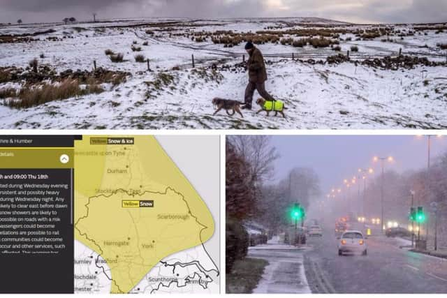

"Travel delays are possible on roads with a risk that some vehicles and passengers could become stranded. Delays or cancellations are possible to rail and air travel.
Weather warning: Snow and high winds continue to batter Yorkshire as forecast predicts extended cold blast"Very strong winds will affect parts of the UK during Wednesday night and into Thursday. The strongest winds are expected to transfer eastwards across the warning area before clearing by late morning. Road, rail and ferry services may be affected, with longer journey times and cancellations.
"Some rural communities could become cut off. Power cuts may occur and other services, such as mobile phone, may be affected. This warning has been updated with the southern boundary extended further south over northern England. Also, northern parts of Northern Ireland have been added to the warning area."
Advertisement
Hide AdAdvertisement
Hide AdThe Met Office chief forecaster's statement adds: "A deepening area of low pressure is expected to track east across the UK during Wednesday night and into Thursday. Across some central or northern areas, a spell of persistent and perhaps heavy snow may develop.
"This could see 3-8 cm of snow accumulate in places with up to 20 cm over high ground. There remains uncertainty regarding the extent and location of any heavy snowfall."
The snow will have died out by Thursday morning, but the county will remain on yellow alert as high winds blow across Yorkshire.
VIDEO: Heroic passers-by push and tow stranded ambulance up snow-covered street in West YorkshireThe Met Office warning for between 9pm Wednesday and 11am Thursday states: "Very strong winds will affect parts of the UK during Wednesday night and into Thursday. The strongest winds are expected to transfer eastwards across the warning area before clearing by late morning.
Advertisement
Hide AdAdvertisement
Hide Ad"Road, rail and ferry services may be affected, with longer journey times and cancellations. There is also a possibility that some bridges may close."
The chief forecaster adds: "During Wednesday night and into Thursday there is the potential for gusts of 60-70 mph quite widely and a small chance of winds reaching 80 mph in places.
Thundersnow could hit Yorkshire and north of England as Arctic blast continues"The location of the most damaging winds is still uncertain, although parts of northwest England and north Wales currently look most likely. The strongest winds may then transfer to eastern parts of England by the morning.
Some southern parts could still miss the worst of the conditions. Along with the strong winds a spell of heavy rain can also be expected, which could also be combined with a temporary thaw of lying snow in the north, leading to some surface water flooding in places."
Read more:
Advertisement
Hide AdAdvertisement
Hide AdThundersnow could hit Yorkshire and north of England as Arctic blast continuesTraffic and schools around Yorkshire affected by icy weather conditionsWeather warning: Snow and high winds continue to batter Yorkshire as forecast predicts extended cold blastVIDEO: Heroic passers-by push and tow stranded ambulance up snow-covered street in West YorkshireDelays, crashes and vehicles stranded as snowy weather causes disruption across West Yorkshire